Rangitoto is an Auckland natural icon. Located in the Hauraki Gulf, this dormant island-volcano provides a distinctive scenery of an almost symmetrical volcanic cone.
 |
| Rangitoto Island |
Rangitoto is the youngest and the largest of all the volcanoes in the Auckland Volcanic Field. Geologists believe that Rangitoto's most recent eruption only happened 600 years ago. Also, they indicate that it had produced the most amount of lava compared to the other volcanoes in the volcanic field.
A tour of Rangitoto is one of the most popular day-trips in Auckland. With an area of about 5.5 kilometres, a range of leisure and recreational activities can be undertaken on the island, which include tramping, a guided tour, sightseeing, lava cave spelunking, and swimming.
Getting there
The volcanic island is easily accessible from the Auckland City Centre.
Fullers Ferry sails from the Ferry Terminal to the island, three times a day during weekdays, and five times a day on weekends and public holidays. Return fares start from NZD30 per adult and NZD15 per child.
 |
| A Fullers ferry docked at the Auckland Ferry Terminal |
|
|
I took the 12:15PM service to the island on a sunny Wednesday. After departure from the main terminal, the ferry has to pick-up additional passengers from Devonport wharf before proceeding to the island. In total, the journey time takes about 30 minutes.
After arrival at the Rangitoto wharf, I walked few metres up to main entrance where a Maori gate welcomes visitors. In Maori, Rangitoto means "Bloody Sky". Since the island-volcano was formed just recently, historical accounts say that there were local tribes who witnessed how Rangitoto rose from the sea.
Getting around Rangitoto
 |
| Rangitoto Island walking tracks. Source: www.fullers.co.nz |
There are various ways to explore this island-volcano. Visitors can either follow different walking tracks or join a Volcanic Explorer Tour riding a 4WD road terrain vehicle.
 |
| The Rangitoto Volcanic Explorer Tour 4WD |
For the sake of experiencing physical challenge (and to avoid paying an extra NZD40 for the guided tour), I decided to trek to the crater using the Main Summit Track.
Trek to the Summit Crater
The main track to Rangitoto's summit is more than 2 kilometres and it takes about an hour (one way) from the wharf to finish. This is the most popular and the easiest track leading to summit crater.
I was blessed to have experience a fine day during my day-trip at Rangitoto. This allowed me to wear light clothing (t-shirt and shorts). It was summer in New Zealand when I had this trip; different type of clothing should be worn on winter and windy weather. I recommend wearing light walking shoes or sport shoes for this trek, as opposed to jandals or flip flops.
 |
| Sign indicating the distance from the summit crater. Courtesy of the Depart of Conservation (DOC) |
The main summit track is fairly eroded, so it is rare for visitors to get lost. The rule of thumb is to follow the designated track and everything will be fine.
If you get to the island at a later time of the day, you might be able to encounter visitors walking back to the wharf. It wouldn't hurt to say a simple greeting like 'Hi' or 'How are you?'; this is a customary thing to do in New Zealand. Kiwis are naturally friendly people.
A sunny-day trek at Rangitoto can be favourable to some; however, warm weather can be a disadvantage in doing the trek.
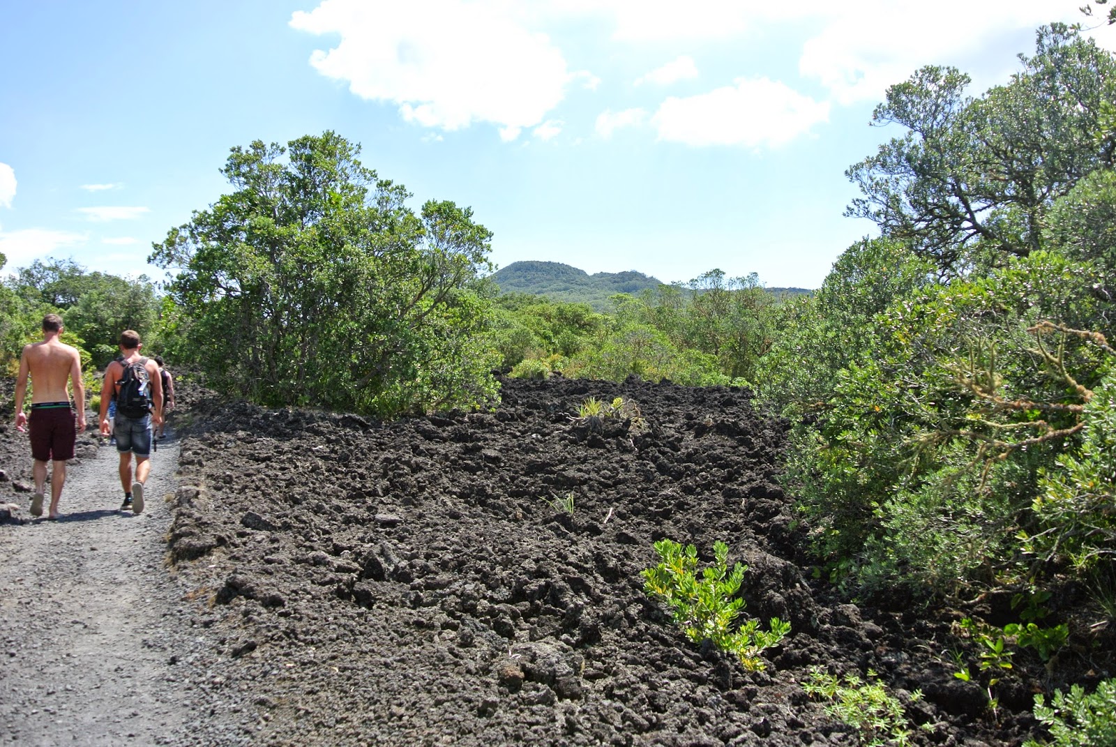
The main track follows the path of lava erupted by the volcano! According to the Department of Conservation, 95% of the island-volcano is covered in lava rocks. The molten lava, in the form of black basaltic rocks, absorb and reflect the heat from the sun.
 |
| Rangitoto's basalt rock field |
The extra heat produced by the black rocks resulted in extra humidity and uncomfortable feeling. I was sweating as I continue my way up to the crater, that's why it is recommended to bring lots of water and extra clothes. Nevertheless, walking on an actual lava path is a unique experience I had in Rangitoto.
 |
| Visitors taking a break and educating themselves about Rangitoto's conception | |
|
|
|
|
|
Information panels can be found
along the main summit track. Built on molten lava rocks, these
interpretive provisions are effective tools is educating independent
visitors, like myself, who chose not to join a guided tour. Basically, these
information panels illustrate that Rangitoto was formed from a series of
eruption that started 600 years ago and lasted for years.
 |
| Interpretive information panels. Rangitoto summit on the background |
Is it believed to erupt again? Probably, although geologists say it is unlikely to erupt again.
 |
| A view of Auckland CBD from Rangitoto Island | |
|
|
|
|
|
|
One of the features of a Rangitoto tour is for visitors to enjoy stunning and refreshing view of Auckland. Scenic look-outs are provided to get different views of the city; these provide you the chance to take occasional short stops and selfies!
 |
| The main summit track's shaded trail. |
As I've ascended up to the summit, the trail led me to a bushwalk that made the trek easier as the shade provided cooler temperature. Along this part of the trail, pohutukawa (New Zealand Christmas tree) and different types of ferns can be found. Various species of bird can be encountered too.
 |
| Picnic grounds at Rangitoto Island |
About 15 minutes to the crater, a picnic spot is provided for visitors. This is a perfect place for those who want to take a quick lunch break before proceeding to the summit. However, Rangitoto Island is a protected from pests to protect wildlife so it is essential to keep and bring rubbish out of the island.
 |
| Towering trees covering the once lifeless lava field of Rangitoto |
Instead of eating my packed lunch, I decided to continue to walk towards the crater. During this stage, that feeling of unexplained excitement hit me again knowing that the crater is few metres away from where I stood.
Reaching the crater
 |
| Rangitoto crater observation deck |
An information panel signals that I made it to the crater. Beside it is an observation deck to get an close view of the crater.
 |
| Rangitoto crater covered with thick fern and pohutakawa forest |
Like most of the volcanic cones in Auckland, the summit of Rangitoto is a cinder or scoria cone with a crater.
It is quite underwhelming seeing the crater for the first time. It is basically covered with vegetation. However, this arena-like feature houses unique species of ferns that only grow on the crater, and no where else in the island. Also, it is noticeable that plants hardly grow at the centre part of the crater.
 |
| Survey marker at the summit of Rangitoto |
Few metres walk from the crater observation deck is Rangitoto's highest peak. From here, unobstructed views of Auckland CBD, North Shore, and Hauriki Gulf await.
 |
| 360 degree view from the summit. Left to right: Crater, Motutapu Island, Browns Island, and Auckland CBD |
 |
| Front to back: Forest-covered lava field, Devonport suburb, Auckland CBD |
 |
| Browns Island, another island-volcano in Auckland |
After enjoying the view from the summit and taking a few selfies, I decided to trek back to wharf. This is also the best time to explore the lava caves formed by Rangitoto's previous eruptions.
 |
| Lava caves entrance |
 |
| Standing on a lava cave entrance |
 |
| Inside a lava cave |
How are lava caves different from normal caves? I've noticed that
compared to the latter, lava caves do not feature stalactites and
stalagmites. Moreover, the walls of a lava cave contain some sharp
edges that's why extra care need to be considered to avoid getting bruises.
 |
| Department of Conservation (DOC) Rangers who take care of Rangitoto |
Rangitoto is just one of Auckland volcanoes, but what make it unique are its size, geology, biodiversity, and the range of recreational and educational activities that can be experienced on the island. The feeling when I was viewing its crater may not be as exciting and exhilarating compared to watching the spectacle of a geothermal or volcanic activity.
However, being on the island and witnessing the unique biodiversity made me realised how amazing is it for the flora to rise from lifeless lava rocks. Truly, life would not be complete without volcanoes! Yes, these landforms can be deadly but volcanoes, like Rangitoto, can be a venue for a richer and diverse life to live and grow.
Note:
Photographs are owned by the blogger (unless, otherwise specified) and should not be used without his permission.


Thanks for all the information, is really well documented! I´ll be visiting Rangitoto for sure after reading your post.
ReplyDeleteI´m going to Auckland in February and wondering what type of clothes should I take? I know is summer time, but I´ve read that climate can vary a lot. Thank you!
Hi Ana! Thank you very much. I visited Rangitoto on the first week of March (tail-end of summer in the Southern hemisphere) and it can get warm during that time of the year. Also, the trail is composed of basaltic rocks that emit heat, so I recommend you wear light clothing and bring plenty of water. It is also true that Auckland weather can really get unpredictable, so I suggest to check the weather forecast too. But in general, Auckland weather is the best in February. Wishing you a great trip ahead! Cheers!
DeleteThanks for the recommendation. If you want more information on Auckland, visit website.
ReplyDelete